Consulting

News / Blog

Custom topographic relief map for stone cartography art installation

Custom topographic relief map for stone cartography art installation

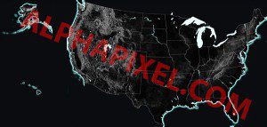
Client: Stone Innovations Description : AlphaPixel and Red Geographics partnered to create a spectacular large relief map of the United States, to be machine etched into polished black stone and hand painted with hydrography features for an artistic installation for a private client. Stone Innovations of Wisconsin led the project and performed the installation. This is

Read More »

NVidia Jetson TK1 Yocto Implementation

Client: Confidential embedded client Description : AlphaPixel has developed an optimized Yocto BSP layer for NVidia’s new Jetson TK1 Tegra K1 platform. The Jetson TK1 is a high-performance ARM Cortex A15-based platform supporting OpenGL 4.4 with 192 GPU cores in an inexpensive and compact form factor perfect for mobile and embedded applications. The Yocto Project

Read More »

OpenSceneGraph and OSGEarth Yocto Profiles

Client: Confidential embedded client Description : AlphaPixel has successfully ported OSG, osgEarth, GDAL and their various dependencies to the Yocto/OpenEmbedded project. With these tools, developers can now create custom, extremely minimal embedded Linux images and appliances with FULL OSG support for any of the variety of (including a multitude of ARM and all x86) platforms.

Read More »
FME Data Inspector GIS Data Paging and Display

FME Data Inspector GIS Data Paging and Display

Client: Safe Software Description : AlphaPixel developed a virtual-paging database interface to FME’s internal geospatial data store for FME’s OpenSceneGraph-based Data inspector. FME (Feature Manipulation Engine), a spatial ETL (Extract, Transform, Load) tool, contains a sub-module known as Data Inspector for inspecting data at any stage of the data pipeline. This tool pulls data from

Read More »
3D View of terrain of railroad yard

Terrain / VirtualPlanetBuilder Consultation

Client: New York Air Brake Train Dynamic Systems Description : Provided consultation on OpenSceneGraph terrain visualization topics for freight train simulator visuals. Designed VPB integration and custom depth partitioning schemes to manage multi-resolution terrain databases. Constructed custom tools for building small subsets of VPB terrain affected by terrain updates, and custom shaders to render geotypical

Read More »
Screenshot of LIDAR data

Shader-based LIDAR Simulation

Client: Ball Aerospace Description : AlphaPixel, with Skew Matrix Software contributed training and consulting in support of Ball’s development of a realtime system allowing joystick-driven ‘flight’ of an airborne LIDAR mapping sensor over large-area landscapes built from USGS survey data. Subsequently AlphaPixel provided similar support in the development of shader-based implementation of material surface properties,

Read More »

European Flight Simulation Support

Client: COMPRO Computer Services Description : Assisted in troubleshooting and improving OpenSceneGraph and OpenFlight based flight simulation tools in support of European national defense clients.  

Read More »
OSG port to OpenGL ES2/EGL

OSG port to OpenGL ES2/EGL on iMX51 embedded SBC

Client: Confidential embedded user interface hardware/software company. Description: AlphaPixel performed a port of OpenGL to a Freescale iMX51 based single board computer system running Linux without XWindows targeting OpenGL ES2 via EGL. This was particularly challenging because OpenSceneGraph’s EGL implementation only supports Linux, but still requires the XGL APis. This port utilized the OSGViewerEmbedded class

Read More »
Scroll to top

connect

Have a difficult problem that needs solving? Talk to us! Fill out the information below and we'll call you as soon as possible.

Diagram of satellite communications around the Earth